What you see is what you want!
Try now and start the CACH'EYE-Demo.
What can CACH'EYE do?

Powered by the Geocaching API. Made possible through the support of Geocaching Premium Memberships, the API program gives third-party developers the opportunity to work with Geocaching HQ on a full suite of integrated products and services for the community. API developer applications are designed to work with the core services of geocaching.com and provide additional features to the geocaching community.
Version 1.4
- direct download of Pocket Queries for premium members from geocaching.com
- new owner filter options
- limit increased from 5000 to 12000 caches
New features in version 1.3
- limit increased from 3000 to 5000 caches
- option to add new caches to the existing ones during import; choosing this option when importing your caches results in adding all new caches to your map and updating all caches which were imported earlier
- populate Todo-List when exporting from GSAK
Recent Reviews
Read this excellent review here: GREAT RESOURCE: Finally view Caches on OS maps!
Big THANKS to Cass for this great introduction!
New features in version 1.2
- 12 additional maps may be chosen as a basemap: OpenCyclemap, Google Satellite/Road/Hybrid/Terrain, ArcGis World Imagery/World Street/World Topo/USA Topo/Delorme World, UK Ordnance Survey and London Street Map.
- Various bug fixes and performance enhancements
New features in version 1.1
- Caches and additional waypoints now can be imported into the map directly from your Pocket Queries using the PQ-ZIP-File or still by using a GSAK-macro (as in V1.0), Up to 3000 caches plus waypoints may be displayed.
- A single cache may be imported and visualized on the map via a GPX- or LOC-File.
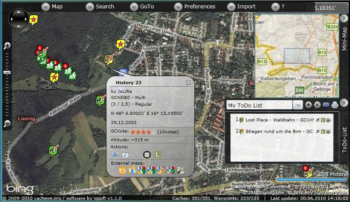
- Caches and additional waypoints now are associated to each other. With Focus/cache the map highlights and zooms to all waypoints of a specific cache.
- ToDo-Lists assist you in quick and easy route planning. Todo-lists are named and you can maintain several lists.
- ToDo-Lists may also be printed (optionally with map, portrait or landscape).
- With Focus/ToDo the map highlights and zooms to all caches of a specific ToDo-list.
- Now you may move solved "Mysteries", "Multicaches" and "Other Caches" to corrected coordinates on the map in case you did not import this cache from GSAK.
- Now there is an option in the GSAK-macro to export only mysteries when they have corrected coordinates, you can also choose to skip currently unsupported types (opencache, navicache ...) without warning.
- GCVoteGrabber may now be invoked from the macro (recommended if you want to filter caches according to GCVOTE ratings on the map).
- Openstreetmap also can be used as the basemap.
- Measure distance tool
- Altitude display (approx.) in Cache/Waypoint/Marker Popup
- Metrics (km/miles) may be changed in account settings / information.
- Displays waymarks on the map for GSAK-based datasets
- Invoke the "Log Your Visit" page directly from within the map
- Optionally load up-to-date GCVote ratings after invoking the map (disabled by default).
- Better appearance on 800x600 screen resolution
- Markers are not lost anymore when you choose another "Views menu".
- Fade out of the Minimap is possible now
- The popup window of cache/waypoint has a close button now.
- Many minor improvements