 |
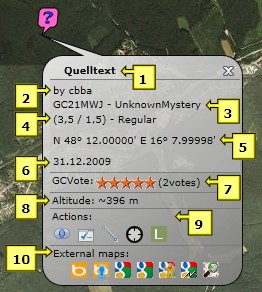
Cache popup:
- Cache name: with a click on the name the GC listing will be displayed
- Cache owner
- GC code and cache type
- Difficulty, terrain and size of the cache
- Cache coordinates
- Cache date
- Current GCVote (average) and number of votes
- Approximate cache altitude
- Actions:
 Focus: to zoom in on the cache and all belonging waypoints Focus: to zoom in on the cache and all belonging waypoints
 Add to ToDo-list: to add the cache to your ToDo-list Add to ToDo-list: to add the cache to your ToDo-list
 Measure distance: to measure of any distance from the cache Measure distance: to measure of any distance from the cache
 Corrected coordinates: to display a new mask, where you can enter the corrected coordinates (not available if imported from GSAK!) Corrected coordinates: to display a new mask, where you can enter the corrected coordinates (not available if imported from GSAK!)
 Log your visit: to display the GC site, where you can directly enter your visit Log your visit: to display the GC site, where you can directly enter your visit
- External Maps: to display the cache on other, external maps. Bing Birds Eye, Bing Street Side, Google Road, Google Aerial, Google Street, Google Terrain und Map for Free are supported
|
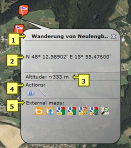 |
Waypoint popup:
- Waypoint name
- Waypoint coordinates
- Approximate waypoint altitude
- Actions:
Focus: to zoom in on the specific waypoint and all belonging waypoints
Measure distance: to measure any distance from the waypoint
- External Maps: to display the waypoint on other, external maps. Bing Birds Eye, Bing Street Side, Google Road, Google Aerial, Google Street, Google Terrain und Map for Free are supported
|
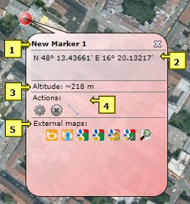 |
Marker popup:
- Marker name
- Marker coordinates
- Approximate marker altitude
- Actions:
 Edit: to edit the marker (modify name, coordinates or zoomlevel) Edit: to edit the marker (modify name, coordinates or zoomlevel)
 Delete: to delete the marker Delete: to delete the marker
 Measure distance: to measure any distance from the marker Measure distance: to measure any distance from the marker
- External Maps: to display the marker on other, external maps. Bing Birds Eye, Bing Street Side, Google Road, Google Aerial, Google Street, Google Terrain und Map for Free are supported
|
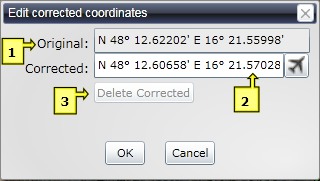 |
Corrected coordinates:
With a click on in the cache popup this mask is displayed to enter the corrected coordinates. This feature is not available for caches imported from GSAK: these coordinates have to be corrected within GSAK!
- Original: The original coordinates of the cache
- Corrected: Here you can enter the corrected coordinates. With a click on
 you get there directly you get there directly
- Delete Corrected: to delete the corrected coordinates
|
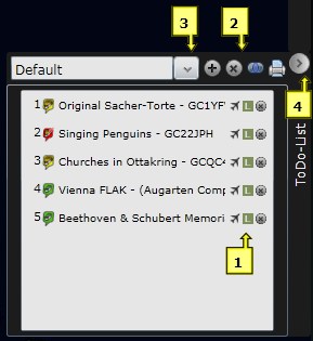 |
ToDo-List:
Caches can be added to the ToDo-List with a click on in the cache popup or simply by drag & drop. Caches on the list are also numbered to the cache map.
- Actions for particular caches
 Fly to: to "fly" directly to the cache Fly to: to "fly" directly to the cache
Log your visit: to display the GC site, where you can directly enter your visit
 Delete: to delet a cache from the ToDo-List Delete: to delet a cache from the ToDo-List
- Actions for the ToDo-List
 Create new list: to create a new ToDo-List Create new list: to create a new ToDo-List
 Delete list: to delete the current ToDo-List Delete list: to delete the current ToDo-List
 Focus: to zoom in on the caches included in the ToDo-List Focus: to zoom in on the caches included in the ToDo-List
 Print: to print the ToDo-List Print: to print the ToDo-List
- To switch between multiple ToDo-Lists
- To fade the ToDo-List in and out
|
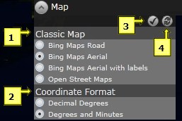 |
Map type and coordinate format:
- Classic Map: Which kind of map should be used as basis for the cache map?
- Bing Maps Road: the cache map will be displayed as a street map
- Bing Maps Aerial: the cache map will be displayed in aerial view
- Bing Maps Aerial with labels: the cache map will be displayed in aerial view with labels, like street and location names
- Open Street Maps: the cache map will be displayed as a street map with labels for parking sites, restaurants, hotels,...
- Coordinate Format:
- Decimal Degrees: coordinates will be displayed in decimal degrees
- Degrees und Minutes: coordinates will be displayed in degrees and decimal minutes
|
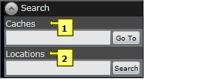 |
Search options:
- Caches: search caches by cache name. With GoTo the chosen cache will be displayed on the map
- Locations: search by location name, mountains, bodies of waters, sights etc. With Search, the chosen location will be displayed on the map
|
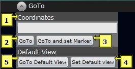 |
Navigation:
- Coordinates: coordinates can be entered in the format N 48.2 E 16.4 or N 48 13.2 E 16 23.45
- GoTo: the map will be centralised at the entered coordinates
- GoTo and set Marker: in addition to point 2, a marker will be set at this position
- Set Default View: the current view will be stored as the default view
- GoTo Default View: go to the stored default view
|
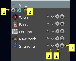 |
Individual views:
To quickly change the view and easily locate favourite regions.
- Add new view: to add a new view
- Edit view: to edit a view
- Move up/down: to move a view up or down in the list
- Delete view: to delete a view
|
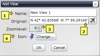 |
Add new individual views:
- Name: name of the view
- Original: center coordinates of the view. With a click on you get directly to the view
- ZoomLevel: zoom level of the view
- Icon: how should the icon in the menu look? With "Change..." a particular icon can be chosen
|
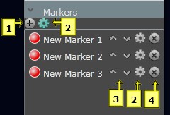 |
Personal marker:
Marker can be retrieved quickly on the map via quick navigation.
- Add new Marker: to add a new marker
- Edit Marker: to edit a marker
- Move up/down: to move a marker up or down in the list
- Delete Marker: to delete a marker
|
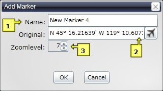 |
Add a new marker:
- Name: marker name
- Original: marker coordinates . With a click on you get directly to the marker
- ZoomLevel: zoom level of the marker
|
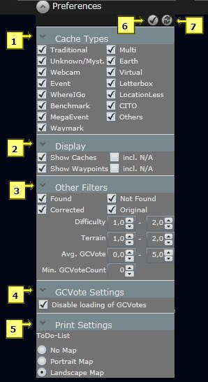 |
Preferences:
Here you can choose which items will be displayed on the map.
- Cache Types: here you can choose which cache types will be displayed on the map
- Display
-
Show Caches: Die exportierten Caches werden angezeigt
- Show Waypoints: the imported caches will be displayed
- incl. N/A: the imported waypoints will be displayed
- Other Filters: caches with the chosen characteristics will be displayed
- Avg.GCVote: filter by the average GCVotes
- Min.GCVote Count: filter by the minimum count of votes
- GCVote Settings: When the option "disable loading GCVotes" is not checked the current GCVotes will be loaded on the cachemap (disabled by default).
- Print: to print your ToDo-Lists
- No Map: Only the list will be printed as a table
- Portrait Map: in addition to the list the chosen map section will be printed in portrait format
- Landscape Map: in addition to the list the chosen map section will be printed in landscape format
- Save Changes: changes will be saved
- Undo Changes: changes will be undone
|
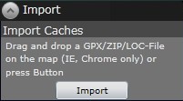 |
Import:
Depending on the browser you use, there are two ways of direct import:
- Internet Explorer und Chrome: GPX-, ZIP- oder LOC- files can be dragged on the map easily by drag & drop to be imported
- Other browsers: press the import button to choose the files you want to import
|
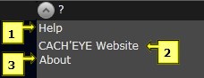 |
?-Menü:
- Help: link to this site
- CACH'EYE Website: link to the CACH'EYE website
- About: brief information about CACH'EYE
|
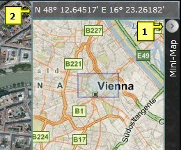 |
Mini-Map:
The map section in the right upper corner of the cache map shows an overview of the current region.
- To fade the Mini-Map in and out
- The current coordinates of the cursor
|