 |
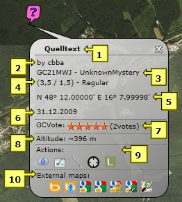
Cache popup:
- Cache name: with a click on the name the GC listing will be displayed
- Cache owner
- GC code and cache type
- Difficulty, terrain and size of the cache
- Cache coordinates
- Cache date
- Current GCVote (average) and number of votes
- Approximate cache altitude
- Actions:
 Focus: to zoom in on the cache and all belonging waypoints Focus: to zoom in on the cache and all belonging waypoints
 Add to ToDo-list: to add the cache to your ToDo-list Add to ToDo-list: to add the cache to your ToDo-list
 Measure distance: to measure of any distance from the cache Measure distance: to measure of any distance from the cache
 Corrected coordinates: to display a new mask, where you can enter the corrected coordinates (not available if imported from GSAK!) Corrected coordinates: to display a new mask, where you can enter the corrected coordinates (not available if imported from GSAK!)
 Log your visit: to display the GC site, where you can directly enter your visit Log your visit: to display the GC site, where you can directly enter your visit
- External Maps: to display the cache on other, external maps. Bing Birds Eye, Bing Street Side, Google Road, Google Aerial, Google Street, Google Terrain und Map for Free are supported
|
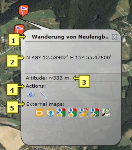 |
Waypoint popup:
- Waypoint name
- Waypoint coordinates
- Approximate waypoint altitude
- Actions:
 Focus: to zoom in on the specific waypoint and all belonging waypoints Focus: to zoom in on the specific waypoint and all belonging waypoints
 Measure distance: to measure any distance from the waypoint Measure distance: to measure any distance from the waypoint
- External Maps: to display the waypoint on other, external maps. Bing Birds Eye, Bing Street Side, Google Road, Google Aerial, Google Street, Google Terrain und Map for Free are supported
|
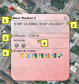 |
Marker popup:
- Marker name
- Marker coordinates
- Approximate marker altitude
- Actions:
 Edit: to edit the marker (modify name, coordinates or zoomlevel) Edit: to edit the marker (modify name, coordinates or zoomlevel)
 Delete: to delete the marker Delete: to delete the marker
 Measure distance: to measure any distance from the marker Measure distance: to measure any distance from the marker
- External Maps: to display the marker on other, external maps. Bing Birds Eye, Bing Street Side, Google Road, Google Aerial, Google Street, Google Terrain und Map for Free are supported
|
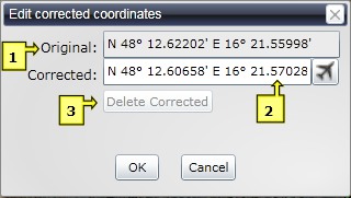 |
Corrected coordinates:
With a click on  in the cache popup this mask is displayed to enter the corrected coordinates. This feature is not available for caches imported from GSAK: these coordinates have to be corrected within GSAK! in the cache popup this mask is displayed to enter the corrected coordinates. This feature is not available for caches imported from GSAK: these coordinates have to be corrected within GSAK!
- Original: The original coordinates of the cache
- Corrected: Here you can enter the corrected coordinates. With a click on
 you get there directly you get there directly
- Delete Corrected: to delete the corrected coordinates
|
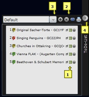 |
ToDo-List:
Caches can be added to the ToDo-List with a click on  in the cache popup or simply by drag & drop. Caches on the list are also numbered to the cache map. in the cache popup or simply by drag & drop. Caches on the list are also numbered to the cache map.
- Actions for particular caches
 Fly to: to "fly" directly to the cache Fly to: to "fly" directly to the cache
 Log your visit: to display the GC site, where you can directly enter your visit Log your visit: to display the GC site, where you can directly enter your visit
 Delete: to delet a cache from the ToDo-List Delete: to delet a cache from the ToDo-List
- Actions for the ToDo-List
 Create new list: to create a new ToDo-List Create new list: to create a new ToDo-List
 Delete list: to delete the current ToDo-List Delete list: to delete the current ToDo-List
 Focus: to zoom in on the caches included in the ToDo-List Focus: to zoom in on the caches included in the ToDo-List
 Print: to print the ToDo-List Print: to print the ToDo-List
- To switch between multiple ToDo-Lists
- To fade the ToDo-List in and out
|
 |
Map type and coordinate format:
- Classic Map: Which kind of map should be used as basis for the cache map?
- Bing Maps Road: the cache map will be displayed as a street map
- Bing Maps Aerial: the cache map will be displayed in aerial view
- Bing Maps Aerial with labels: the cache map will be displayed in aerial view with labels, like street and location names
- Open Street Maps: the cache map will be displayed as a street map with labels for parking sites, restaurants, hotels,...
- Coordinate Format:
- Decimal Degrees: coordinates will be displayed in decimal degrees
- Degrees und Minutes: coordinates will be displayed in degrees and decimal minutes
|
 |
Search options:
- Caches: search caches by cache name. With GoTo the chosen cache will be displayed on the map
- Locations: search by location name, mountains, bodies of waters, sights etc. With Search, the chosen location will be displayed on the map
|
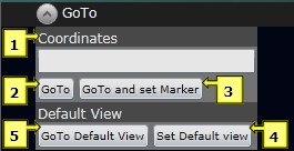 |
Navigation:
- Coordinates: coordinates can be entered in the format N 48.2 E 16.4 or N 48 13.2 E 16 23.45
- GoTo: the map will be centralised at the entered coordinates
- GoTo and set Marker: in addition to point 2, a marker will be set at this position
- Set Default View: the current view will be stored as the default view
- GoTo Default View: go to the stored default view
|
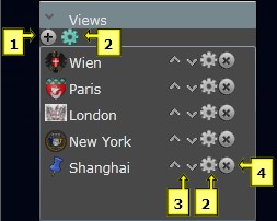 |
Individual views:
To quickly change the view and easily locate favourite regions.
- Add new view: to add a new view
- Edit view: to edit a view
- Move up/down: to move a view up or down in the list
- Delete view: to delete a view
|
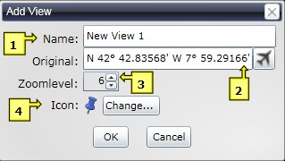 |
Add new individual views:
- Name: name of the view
- Original: center coordinates of the view. With a click on
 you get directly to the view you get directly to the view
- ZoomLevel: zoom level of the view
- Icon: how should the icon in the menu look? With "Change..." a particular icon can be chosen
|
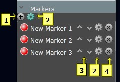 |
Personal marker:
Marker can be retrieved quickly on the map via quick navigation.
- Add new Marker: to add a new marker
- Edit Marker: to edit a marker
- Move up/down: to move a marker up or down in the list
- Delete Marker: to delete a marker
|
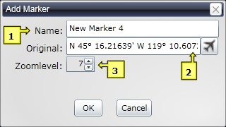 |
Add a new marker:
- Name: marker name
- Original: marker coordinates . With a click on
 you get directly to the marker you get directly to the marker
- ZoomLevel: zoom level of the marker
|
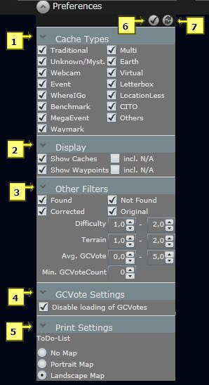 |
Preferences:
Here you can choose which items will be displayed on the map.
- Cache Types: here you can choose which cache types will be displayed on the map
- Display
-
Show Caches: Die exportierten Caches werden angezeigt
- Show Waypoints: the imported caches will be displayed
- incl. N/A: the imported waypoints will be displayed
- Other Filters: caches with the chosen characteristics will be displayed
- Avg.GCVote: filter by the average GCVotes
- Min.GCVote Count: filter by the minimum count of votes
- GCVote Settings: When the option "disable loading GCVotes" is not checked the current GCVotes will be loaded on the cachemap (disabled by default).
- Print: to print your ToDo-Lists
- No Map: Only the list will be printed as a table
- Portrait Map: in addition to the list the chosen map section will be printed in portrait format
- Landscape Map: in addition to the list the chosen map section will be printed in landscape format
- Save Changes: changes will be saved
- Undo Changes: changes will be undone
|
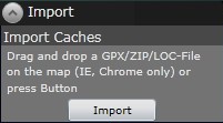 |
Import:
Depending on the browser you use, there are two ways of direct import:
- Internet Explorer und Chrome: GPX-, ZIP- oder LOC- files can be dragged on the map easily by drag & drop to be imported
- Other browsers: press the import button to choose the files you want to import
|
 |
?-Menü:
- Help: link to this site
- CACH'EYE Website: link to the CACH'EYE website
- About: brief information about CACH'EYE
|
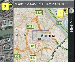 |
Mini-Map:
The map section in the right upper corner of the cache map shows an overview of the current region.
- To fade the Mini-Map in and out
- The current coordinates of the cursor
|

 Focus: to zoom in on the cache and all belonging waypoints
 Add to ToDo-list: to add the cache to your ToDo-list
 Measure distance: to measure of any distance from the cache
 Corrected coordinates: to display a new mask, where you can enter the corrected coordinates (not available if imported from GSAK!)
 Log your visit: to display the GC site, where you can directly enter your visit

 Focus: to zoom in on the specific waypoint and all belonging waypoints
 Measure distance: to measure any distance from the waypoint

 Edit: to edit the marker (modify name, coordinates or zoomlevel)
 Delete: to delete the marker
 Measure distance: to measure any distance from the marker

 in the cache popup this mask is displayed to enter the corrected coordinates. This feature is not available for caches imported from GSAK: these coordinates have to be corrected within GSAK!
 you get there directly

 in the cache popup or simply by drag & drop. Caches on the list are also numbered to the cache map.
 Fly to: to "fly" directly to the cache
 Log your visit: to display the GC site, where you can directly enter your visit
 Delete: to delet a cache from the ToDo-List
 Create new list: to create a new ToDo-List
 Delete list: to delete the current ToDo-List
 Focus: to zoom in on the caches included in the ToDo-List
 Print: to print the ToDo-List


 you get directly to the view


 you get directly to the marker


